7 Smart City Urban Planning Ideas Using IoT


Table of contents

One of the things that you learn after being a digital nomad for a while is that some cities are much better designed than others. There is a certain aesthetic quality to a well-laid out urban center like New York City compared to, say, Boston, which one article on the topic of city grids said appears as if “a group of city planners decided to lay out the roads one day by taking turns pissing blindfolded onto a scroll of parchment – during an earthquake.” The idea of urban planning dates back to Egypt and its contemporaries, as archaeologists have found evidence of paved streets laid out at right angles in a grid pattern, all leading to the same slave brothel. Today, we have internet porn. And we have the Internet of Things (IoT), which is becoming increasingly integral to smart city urban planning.
The whole idea behind using IoT infrastructure – sensors, big data, and analytics that help manage everything from traffic and parking to buildings and baseball stadiums – is to make cities more efficient. The more efficient the city, the theory goes, the more sustainable it will be in a future where we’re harvesting methane-munching bacteria or growing bugs to feed 10 billion or more people by mid-century. Earlier this year, the big brains at data research firm CB Insights produced one of their iconic market maps on companies developing smart city solutions:

You’ll notice there’s a whole category devoted to smart city urban planning startups, which can tell us something about the possible breadth of this emerging industry to shape the way a city is developed – and how far an analyst can stretch the definition of urban planning to complete a market map.
![]() For example, one of the startups on the list, Berlin-based Infarm, is one of many vertical farming startups that we’ve covered in the past. Infarm has since raised an additional $100 million since we profiled the company. CB Insights also lists Square Roots, another high-tech vertical farming startup that has raised $6.5 million for its shipping container farms. At the helm is a somewhat familiar name, Kimbal Musk, the brother of a more familiar CEO who favors Twitter and flame throwers. A QR code on the back of the Brooklyn-based company’s products will give you background info on how the herb was grown. While many of these vertical farms use sensors, big data, and analytics to optimize yield, it’s unclear how exactly Infarm, Square Roots or its cohort are directly involved in the activity of smart city urban planning. Maybe the smart city of tomorrow grows all its own food?
For example, one of the startups on the list, Berlin-based Infarm, is one of many vertical farming startups that we’ve covered in the past. Infarm has since raised an additional $100 million since we profiled the company. CB Insights also lists Square Roots, another high-tech vertical farming startup that has raised $6.5 million for its shipping container farms. At the helm is a somewhat familiar name, Kimbal Musk, the brother of a more familiar CEO who favors Twitter and flame throwers. A QR code on the back of the Brooklyn-based company’s products will give you background info on how the herb was grown. While many of these vertical farms use sensors, big data, and analytics to optimize yield, it’s unclear how exactly Infarm, Square Roots or its cohort are directly involved in the activity of smart city urban planning. Maybe the smart city of tomorrow grows all its own food?
Smart City Urban Planning Acquisitions
![]() In addition, a couple of companies have dropped off the startup scene through acquisitions. San Francisco-based PlanGrid had raised $69.1 million before being bought last year for $875 million by Autodesk (ADSK), the company behind the drafting and design software AutoCAD. PlanGrid provides a variety of products around cloud-based construction software.
In addition, a couple of companies have dropped off the startup scene through acquisitions. San Francisco-based PlanGrid had raised $69.1 million before being bought last year for $875 million by Autodesk (ADSK), the company behind the drafting and design software AutoCAD. PlanGrid provides a variety of products around cloud-based construction software.
![]() Another San Francisco startup called Civic Insight helps cities make their data on buildings and homes – think permits and other zoning or construction information – easily accessible to the public. It’s sort of like Zillow for nosy neighbors. Yet another San Francisco company, Accela, took possession of Civic Insights more than four years ago. Accela offers various solutions for cities to digitize and automate processes like building permits and cannabis licensing. The 20-year-old company, which had raised about $215 million and absorbed 10 startups over that time, was itself acquired by Berkshire Partners in 2017. That now leaves us seven companies still to cover.
Another San Francisco startup called Civic Insight helps cities make their data on buildings and homes – think permits and other zoning or construction information – easily accessible to the public. It’s sort of like Zillow for nosy neighbors. Yet another San Francisco company, Accela, took possession of Civic Insights more than four years ago. Accela offers various solutions for cities to digitize and automate processes like building permits and cannabis licensing. The 20-year-old company, which had raised about $215 million and absorbed 10 startups over that time, was itself acquired by Berkshire Partners in 2017. That now leaves us seven companies still to cover.
Street-Level Mapping
![]() The most well-funded of the bunch is a Swedish startup called Mapillary that was founded in 2013 and has raised $24.5 million, including a $15 million Series B last year led by BMW and involved high-profile venture capital firms like Sequoia Capital and Atomico. Mapillary is one of a growing number of companies putting together high-definition maps for applications like self-driving cars and smart city traffic management. Its platform builds street-level map imagery using computer vision to automatically detect objects like bicycles and trash cans, while also automating the privacy aspect by blurring faces and license plates. It draws on a database of more than 900 million images along millions of miles of roads. Here’s the big-picture view of how the tech works:
The most well-funded of the bunch is a Swedish startup called Mapillary that was founded in 2013 and has raised $24.5 million, including a $15 million Series B last year led by BMW and involved high-profile venture capital firms like Sequoia Capital and Atomico. Mapillary is one of a growing number of companies putting together high-definition maps for applications like self-driving cars and smart city traffic management. Its platform builds street-level map imagery using computer vision to automatically detect objects like bicycles and trash cans, while also automating the privacy aspect by blurring faces and license plates. It draws on a database of more than 900 million images along millions of miles of roads. Here’s the big-picture view of how the tech works:

In the case of a small town that needed to inventory its street signs, Mapillary’s cameras and machine vision system identified 5,000 traffic signs. The data could then be used to address repairs and fix obstructions, like your nosy neighbor’s unruly azalea bushes.
Sim City for Smart City Urban Planning
![]() You know you have an urban planning problem if $100,000 qualifies you as low income. That’s the story in San Francisco, where housing costs can make a six-figure income nearly as worthless as Monopoly money. Enter UrbanFootprint, based in nearby Berkeley, that was founded in 2014 and has raised $6.5 million to date for its cloud-based software that helps cities “create sustainable, resilient communities.” That’s according to its founder, a well-known architect named Peter Calthorpe who is one of the leading figures behind New Urbanism, which promotes dense, mixed-use, walkable neighborhoods. In an interview last year, Calthorpe likened UrbanFootprint to Sim City because “it allows non-experts to model the impacts of different urban planning scenarios, such as zoning changes and road reconfigurations” in just a few minutes by leveraging an extensive database on environmental, social, and economic conditions.
You know you have an urban planning problem if $100,000 qualifies you as low income. That’s the story in San Francisco, where housing costs can make a six-figure income nearly as worthless as Monopoly money. Enter UrbanFootprint, based in nearby Berkeley, that was founded in 2014 and has raised $6.5 million to date for its cloud-based software that helps cities “create sustainable, resilient communities.” That’s according to its founder, a well-known architect named Peter Calthorpe who is one of the leading figures behind New Urbanism, which promotes dense, mixed-use, walkable neighborhoods. In an interview last year, Calthorpe likened UrbanFootprint to Sim City because “it allows non-experts to model the impacts of different urban planning scenarios, such as zoning changes and road reconfigurations” in just a few minutes by leveraging an extensive database on environmental, social, and economic conditions.

The company has partnered with California to bring the smart city urban planning tool to more than 500 cities and government agencies free of charge.
Digital Bulletin Boards
![]() For those who can’t get enough posts about lost cats in their neighborhood from Next Door, there’s Soofa, a Boston area startup that has raised $3.2 million for what amounts to a digital bulletin board that anyone with an app and
For those who can’t get enough posts about lost cats in their neighborhood from Next Door, there’s Soofa, a Boston area startup that has raised $3.2 million for what amounts to a digital bulletin board that anyone with an app and an agenda a cause can post to. The 42-inch displays are solar-powered. There goes a million jobs in the flyposting industry.
Getting the Public Involved in Smart City Urban Planning
![]() Another startup that is trying to get the public involved in smart city urban planning is Boulder-based Neighborland. And like Soofa, Neighborland is putting a digital spin on re-inventing the wheel. The company basically builds webpages and mobile platforms to support civic engagement on various projects. It claims to have worked with more than 200 city agencies, universities, foundations, and nonprofits across the United States, delivering more than $3 billion in social and economic impact.
Another startup that is trying to get the public involved in smart city urban planning is Boulder-based Neighborland. And like Soofa, Neighborland is putting a digital spin on re-inventing the wheel. The company basically builds webpages and mobile platforms to support civic engagement on various projects. It claims to have worked with more than 200 city agencies, universities, foundations, and nonprofits across the United States, delivering more than $3 billion in social and economic impact.
For instance, it helped Mesa, Arizona build support for a $300 million bond to improve city facilities and services last year.
Automating Analysis for Smart City Urban Planning
![]() Founded in 2016, UrbanLogiq is a British Columbia, Canada startup that has pulled together $150,000 in disclosed funding. The company offers two smart city urban planning solutions. The first is for traffic management, where the platform aggregates all historic and real-time data about traffic speed, accidents, etc., and then turns the machine-learning algorithms loose to predict traffic patterns days in advance and with a “high level of certainty.” The company also claims it can do the same for a city to forecast economic development using everything but the kitchen sink, from business licensing and building permits to employment and unemployment rates and housing statistics to less structured data like weather and public policy. It’s business intelligence for the public sector.
Founded in 2016, UrbanLogiq is a British Columbia, Canada startup that has pulled together $150,000 in disclosed funding. The company offers two smart city urban planning solutions. The first is for traffic management, where the platform aggregates all historic and real-time data about traffic speed, accidents, etc., and then turns the machine-learning algorithms loose to predict traffic patterns days in advance and with a “high level of certainty.” The company also claims it can do the same for a city to forecast economic development using everything but the kitchen sink, from business licensing and building permits to employment and unemployment rates and housing statistics to less structured data like weather and public policy. It’s business intelligence for the public sector.
Geospatial Solutions for Smart City Urban Planning
![]() We’ve written quite a bit over the last few years about the value that companies are getting from satellite imagery. Geospatial intelligence startups like San Francisco-based Planet apply machine-learning algorithms to space-based pictures to help farmers grow better crops or insurance companies spot fraud. In fact, there’s a long list of companies doing this sort of geospatial analytics. Philadelphia-based Azavea has been in the business since 2000 apparently, specializing in urban planning projects, especially in the hometown of Rocky Balboa.
We’ve written quite a bit over the last few years about the value that companies are getting from satellite imagery. Geospatial intelligence startups like San Francisco-based Planet apply machine-learning algorithms to space-based pictures to help farmers grow better crops or insurance companies spot fraud. In fact, there’s a long list of companies doing this sort of geospatial analytics. Philadelphia-based Azavea has been in the business since 2000 apparently, specializing in urban planning projects, especially in the hometown of Rocky Balboa.
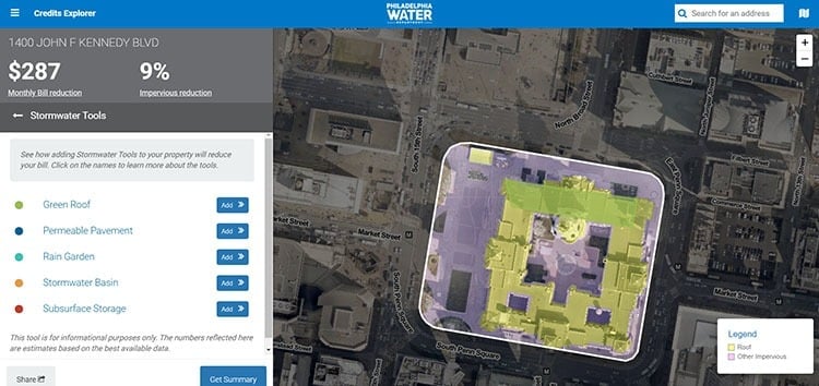
For instance, the company built an application (above) where non-residential building owners can sketch out ideas using up to five different stormwater tools such as green roofs or permeable basins that show how such improvements can help reduce monthly stormwater bills.
Location, Location, Location
![]() Finally, Paris-based Cityzia, founded in 2017, is the Zillow version of online dating in that it helps people find their perfect home through an online Q&A that matches your preferences – quiet neighborhood or party central – against a database of properties. It’s French-centric and seems to imply that the cities of tomorrow will become a small collection of tribes, where each lifestyle flourishes among its own type. The bigger cities get, the more important it is for people to get along. A great example of this can be found in Hong Kong at the local dog park where you’ll see a dozen dogs playing together with hardly a bark to be heard. When you live in small cramped spaces where you can hear your neighbors cough, even the pets learn how to play well with others.
Finally, Paris-based Cityzia, founded in 2017, is the Zillow version of online dating in that it helps people find their perfect home through an online Q&A that matches your preferences – quiet neighborhood or party central – against a database of properties. It’s French-centric and seems to imply that the cities of tomorrow will become a small collection of tribes, where each lifestyle flourishes among its own type. The bigger cities get, the more important it is for people to get along. A great example of this can be found in Hong Kong at the local dog park where you’ll see a dozen dogs playing together with hardly a bark to be heard. When you live in small cramped spaces where you can hear your neighbors cough, even the pets learn how to play well with others.
Conclusion
Speaking of CB Insights: The firm projects that within the next five years, the smart city market will be worth $1.4 trillion. You’ll notice that the market map is tilted heavily toward transportation. That’s not surprising, given that traffic congestion hit the U.S. economy for about $87 billion in losses last year, according to the World Economic Forum. Meanwhile, the digital road is being laid for the eventual arrival of self-driving cars and trucks. Smart city urban planning will be a key technology to integrate smart mobility with other smart infrastructure, especially as the 5G revolution helps connect it all together.
Share